Category Archives: Surveys

Lindal – Mascalles path survey

9 Aug 2026: Survey of FP 602022 by volunteer PQ.

This is a useful footpath that leads from the entrance to Wax Lyrical in Lindal-in-Furness (the old Candle Factory) to near the crossroads where Stone Barrow Lane crosses the lane from Dalton to Little Urswick (called Urswick Road as far as that crossroads, Hooks Lane from there to Little Urswick). From there it is a short walk up Stone Barrow Lane to Verstone kennels & cattery, where the ancient Dimples Hole Lane track leads to two footpaths that go either over or around Little Urswick Crags to the middle of Little Urswick.

The path has 3 main problems: –

  • The kissing gate at P4 is damaged beyond repair and very hard to open & close.
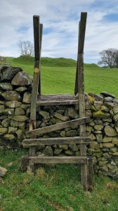
  • The step on the wooden step stile at P5 has collapsed.
  • The kissing gate at P6 is a very tight squeeze to get through, plus has barbed wire close to possible hand holds.

Click photos to enlarge.

P1: Kissing gate near where path leaves London Road at Wax Lyrical, Lindal: (OS Map & Grid Ref)

I forgot to check whether there is a fingerpost where this path leaves the actual lane (London Road). But it is only about 30m across the Wax Lyrical car park to this relatively recently installed tall kissing gate, which is next to a tall gate into the field.
The kissing gate is fine and easy to get through. And although it does not have any waymarks on it, it is fairly easy to see from the lane. And there is a two-way waymark on the stile at P2 immediately beyond the kissing gate, it is fairly easy to see which way to go.

P2: Branch path (OS Map & Grid Ref):

This wooden stile is immediately after the kissing gate, but the Mascalles path being surveyed (FP 602022) does not go over it – instead it continues past it along the edge of the field – since this stile is just the start of path FP 580035, which branches off left and goes to the junction of Halier How Lane and Stone Barrow Lane.
The stile is firm and in good condition and has clear recently -itted new waymarks on both sides, and the ones on the Mascalles path side make it fairly clear that the path to Mascalles goes straight on past it, not over it.

P3: Old Kissing gate into next field: (OS Map & Grid Ref):

The only issues here are that I could not see any waymark for people going towards Lindal, plus the hedge and some nettles are starting to encroach so some more trimming would be useful.
This old kissing gate is OK, opens easily and has a reasonable gap. It looks like it is prone to getting overgrown by the hedge, and there were some nettles very close, so it could do with a bit of clearing. But on the survey date it was OK and the hedge looked like it had been trimmed to keep the kissing gate usable.
There is clear recently fitted new waymark on the Lindal side but no waymark visible from the Mascalles side.

P4: Badly damaged hard-to-use kissing gate (OS Map & Grid Ref):

This old kissing gate is a write-off now and is very hard to use. So it needs to be completely replaced.
The gate hinge post is loose in the ground and leaning, so the gate hanging on it is pressed against the ground and is hard to lift in order to move.
It has also lost one of its vertical bars and the pointed end of another one is exposed and sticking up at the top, a little dangerously.
The cage part of the kissing gate is also badly damaged. So all in all this kissing gate is quite hard to use and still leave in a stock-proof state, and the whole structure needs replacing.
There are recently-fitted new waymarks on both sides.

P5: Wooden stile with collapsed step (OS Map & Grid Ref):

This has nice old stone blocks as steps leading up to it on the Lindal side, with a single wooden step to get over the top of the wooden fence, which is quite firm.
But the support post for that wooden step on the far (Mascalles) side has rotted and collapsed and the step is lying on the ground. The Lindal side wooden support post is still in position and is reasonably firm but does wobble a bit.
So this stile needs the wooden step replacing.

Also, I felt that the recently fitted new waymark pointing onward towards Mascalles is a bit ambiguous. It left me unclear as to whether to go left or right of the clump of trees shown in the photo. The correct way is to the right of them, but the next target (the final kissing gate onto the lane) is not visible from here. So I feel it might be worth refitting that waymark to point is a bit more bearing right.

P6: Tight squeeze kissing gate onto lane (OS Map & Grid Ref):

There are several problems at this old kissing gate: –

  • The main problem is that it’s a very tight squeeze to get through.
  • It is also overgrown a bit on one side by the adjacent hedge.
  • Finally, there is a barbed wire strand very close to you on the other side, which is also wrapped round the road-side fingerpost just where you’re likely to get hold to steady yourself.

The reason the gap between the gate and the cage is very tight is partly that the nice old limestone gatepost on which the gate is hinged (right hand side in 1st photo, from lane side, and left hand side in 2nd photo, from field side) has leaned over towards the cage, and as a result the gap round the gate when passing through is very tight – only about 9½” (235mm).
On the other side of that gatepost (left side in 2nd photo) there is a low stone wall and it looks like over the years it has been pushed over a bit by the heavy stones of the adjacent dry stone wall.
When the W&F countryside access officer visited this with me, she suggested that if the adjacent stones are removed it might be possible to pull the gatepost vertical again, then wedge it in on the gate side, and then rebuild the dry stone wall, with a narrow gap between. But I feel that might still not create a big enough gap and the gatepost might need to be moved further away from the cage in order to get a decent gap to get through.

This photo shows the barbed wire strand, which spans acroos the end of wall just behind the limestone gatepost and is wrapped around the fingerpost with barbs sticking out in a dangerous position.

Pennington area paths surveys

August 2025: Surveys of 3 paths by volunteers MC & PQ:

We surveyed 3 paths after the council countryside access team asked us to look at some problems that had been reported. See this map and the following survey reports: –

These are useful paths that can be linked to form a nice walking route between Lindal and Ulverston on the north-west side of the A590. But at the time of survey they had significant problems, aome of which PathFix has since worked on.

Cumbria Way Path Surveys

June-July 2025: Cumbria Way: Ulverston to Gawthwaite surveys:

The Cumbria Way is the most used walking route in the Furness area. So in late June and early July 2025 volunteer PQ surveyed the Cumbria Way from Ulverston to Gawthwaite, in the following three sections: –

At the time, several known problems on the Ulverston to Windy Ash section had already been fixed by volunteers MC & JW. And since then more problems have also been fixed by PathFix volunteers. The route has also been re-waymarked. See our Cumbria Way page for details.

Surveys of paths from Little Urswick to A590/Green Lane

29th June 2025: Surveys by volunteers LH & MC:

The following rights of way were surveyed in June 2025, since they were on the original route of the Haematite Trail.

ince then, Furness PathFix volunteers SB & LM have re-launched the Haematite Trail with some route changes, and only the first of the following path surveys is on the new route in this area.

Survey of path from Smithy Green Farm (near Greenodd)

Survey by PQ on 19 April 2025:

Map

This is a short section of path near Greenodd, just a few hundred metres long, that starts from a minor lane just south-west of Smithy Green Farm. It goes through the farm and one of its fields before crossing a part-broken wooden stile into a small wood, at the end of which there is another part-broken wooden stile that leads onto the lane just south of St. Mary’s Church above Penny Bridge.

Problem 1: There is no fingerpost or waymark where it sets off from the lane along the farm access track.

Problem 2: At the farm there is no waymark to show which way to go.

The path actually goes through this gate, which is easy to open and then turns left once in the field 20m further on.

The path leaves the field at the far left corner, where there is a broken and part-overgrown stile into the wood beyond.

Problem 3: Although the rails and uprights on this stile are secure, both steps are part rotted and need replacing, and the upper step’s support post on this field side of the stile is loose in the ground and in danger of collapsing (the step support post on the left in first photo).

The second photo is from the other (small wood) side of the stile, looking back over the stile at the farm. The step supports on this side are still firm, but both steps are damaged and need replacing.

Problem 4: just beyond that stile the ground drops down a steep gravelly bank into the wood. This drop is a bit dangerous and it would be very useful if it were stepped to avoid the risk of someone falling.

Problem 5: The small wood is quite attractive, with bluebells and garlic, but the route through it is unclear and there are fallen trees blocking some apparent paths. So some simple path clearing and marking would be useful.

At the end of the wood the path goes over another wooden stile, onto the lane just south of St. Mary’s Church above Penny Bridge .

Problem 6: The lower step on this stile is part broken and needs replacing (the step support posts still seem firm). But also, there is nothing to hold onto when on the upper step (left hand side in photo, which is fro the lane side) since the finger post is too far to reach from there. So a second tall upright hand-hold post on the left (when viewed from the lane) would be useful and make it safer.

The second photo here shows the lower step, which is part-broken on the wood side of the stile.

Survey of Low Scathwaite – Toppin Rays (near Greenodd)

Survey by PQ on 19th April 2025:

Map

I surveyed this path from the Toppin Rays end, where is leaves the lane just north of Toppin Rays Farm, from where it rises over the hill to Low Scathwaite. The finger post where It leaves the lane (up a farm track) has half its finger missing, but it’s still just about readable as saying “Public Footpath”.

At the end of the track it reaches a field gate with a pedestrian gate at the side. This pedestrian gate opens reasobaly easily, but it has dropped a little and now catches against the top of the central metal gatepost and needs a bit of force to get it to open and close.

After that the path climbs over a hill and drops down to a ladder stile over a dry stone wall, with a metal field gate through the same wall a short distance away.

This ladder stile is badly broken and dangerous. The Toppins Ray (south-east) side of it has a missing step, a step that’s loose on the right and part-rotted side rails. The top platform planks are mostly loose, and the Low Scathwaite side of it has even more missing / loose steps, plus the side rails on that side are even more rotted, so PQ feels this existing ladder stile is beyond repair and dangerous. The best temporary solution would be to remove the ladder stile and put waymark signs on the field gate, which is openable and needs to be kept that way. In due course, if the land owner does not want walkers using the field gate, or if diverting the ROW through that gate is deemed unsatisfactory, then a new ladder stile could be erected over the dry stone wall and the waymark signs moved to that new ladder stile.

This is the metal field gate near that dangerous ladder stile.

After that the path passes north of Low Scathwaite Farm to a wooden field gate into a short track that leads to the lane by Low Scathwaite Farm. This wooden gate is very old and hangs from a single top hinge (top left in photo, whioch is viewed from the lane side), so it dangles worryingly when opened and walkers proba bly worry that it is going to fall off or collapse when they open it.